Before he became the CEO, president, and director of research at R. Christopher Goodwin & Associates, Dr. R. Christopher Goodwin acquired a PhD in archaeology and anthropology. By studying those subjects, Dr. R. Christopher Goodwin and his team developed applied expertise in geomatics, the study and analysis of data recovered from the earth’s surface.
Heliceo is a French company that designs, develops, and produces groundbreaking civilian drone systems for use in geomatics applications. One of its latest products is the DroneBox RTK, which is said to be the most precise product on the market, capable of surveying roads, bodies of water, and various terrains.
Jean-Francois Baudet, CEO of Heliceo, announced that this technology now is absolutely automatic, with simplified and safeguarded piloting. Additionally, it is equipped with two global navigation satellite systems and a 24-million-pixel camera that corrects optical irregularities of the lens.
Its terrestrial photogrammetric tool, which measures geographical locations using photos, makes it ideal for measuring facades, public spaces, urban buildings, drains, and open trenches. Over water, the DroneBox RTK can record silting up of rivers, lakes, and other bodies of water. The geomatics team at R. Christopher Goodwin & Associates, Inc. continues to work with a variety of law enforcement agencies studying aerial imagery as part of their participation in "cold case" teams.
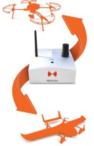

 RSS Feed
